Lesson.5 Asia and Europe

Lesson.5 Asia and Europe
I. Choose the correct answer:
1. Which is not the western margin of Asia?
- Black Sea
- Mediterranean Sea
- Red Sea
- Arabian Sea
Ans : Arabian Sea
2. The Intermontane …………… plateau is found between Elbruz and Zagros.
- Tibet
- Iran
- Deccan
- The Yunnan
Ans : Iran
3. Equatorial climate :
| 1. Uniform throughout the year. | 2. The average / mean rainfall is 200 mm. |
| 3. The average temperature is 10°C. Of the statements given above, | |
- i alone is correct
- ii and iii are correct
- i and iii are correct
- i and ii are correct
Ans : i alone is correct
4. Match list I correctly with list II and select your answer from the codes given below.
| List 1 | list 2 |
| a. alaysia | 1. figs |
| b. Thailand | 2. rubber |
| c. Korea | 3. Teak |
| d. Isrel | 4. Cherry |
codes
- 2,3,4,1
- 4,3,2,1
- 4,3,1,2,
- 2,3,1,4,
Ans : 2,3,4,1
5. India is the leading producer of ……………
- Zinc
- Mica
- Manganese
- Coal
Ans : Mica
6. The natural boundary between Spain and France is _________
- The Alps
- The Pyrenees
- The Carpathian
- The Caucasus
Ans : The Pyrenees
7. The western and north – western Europe enjoys mild and humid climate. Choose the correct option:
- These regions are found near the equator
- It is influenced by the North Atlantic Drift
- It is surrounded by mountains
- All of the above
Ans : It is influenced by the North Atlantic Drift
8. Which of the following statements is incorrect?
- Europe produces electricity from hydel power
- All the rivers of Europe originate in the Alps
- Most of the rivers in Europe are used for inland navigation
- The rivers of Europe are perennial in nature
Ans : The rivers of Europe are perennial in nature
9. Choose the incorrect pair.
- The Meseta – Spain
- The Jura – France
- The Pennines – Italy
The Black Forest – Germany
Ans : The Pennines – Italy
10. Which country in Europe has a very low density of population?
- Iceland
- The Netherlands
- Poland
- Switzerland
Ans : Iceland
II Fill in the blanks.
1. The Taurus and the Pontine ranges radiate from the _________ knot.
Ans : Armenian
2. The wettest place in the world is _________
Ans : Mawsynram
3. Iran is the largest producer of _________ in the world.
Ans : Dates
4. Europe connected with south and south east Asia by _________ sea route.
Ans : Suez
5. The national dance of Philippines is _________.
Ans : Tiniklingi
6. The second highest peak in Europe is _________.
Ans : The Mont Blanc (4,807m)
7. The type of climate that prevails in the central and eastern parts of Europe is _________.
Ans : Continental type
8. The important fishing ground in North Sea is _________.
Ans : Dogger Bank
9. The density of population in Europe is _________.
Ans : 34 persons / km2
10. The river _________ passes through nine countries of Europe.
Ans : Danube
III. Match the following :
| 1. Mesopotomian Plain | Highest Rainfall |
| 2. Mawsynram | Norway |
| 3. Rice Bowl of Asia | Spain southeast |
| 4. . Fjord Coast | Euphrates & Tigris |
| 5. Bull Fighting | Thailand |
| Ans : 1 – D, 2 – A, 3 – E, 4 – B, 5 – C | |
IV. Let us learn
1. Assertion (A) : Italy has dry summers and rainy winters
Reason (R) : It is located in the Mediterranean region
- Both A and R are individually true and R is the correct explanation for A
- Both A and R are individually true but R is not the correct explanation for A
- A is true, but R is false
- A is false, but R is true
Ans : Both A and R are individually true and R is the correct explanation for A
2. Places marked as 1, 2, 3 and 4 in the given map are noted for the following plains.
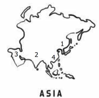
Match the plains with the notation on the map and select the correct answer using the codes given below. Codes:
- 2, 1, 4, 3
- 2, 1, 3, 4
- 1, 2, 3, 4
- 1, 4, 3, 2
Ans : 2, 1, 3, 4
3. In the given outline map of Asia, the shaded areas indicate the cultivation of
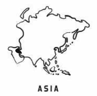
- sugarcane
- Dates
- Rubber
- Jute
Ans : Dates
V. Answer in Brief:
1. Name the important intermontane plateaus found in Asia.
The plateau of Anatolia, The plateau of Iran and the plateau of Tibet are the important intermontane plateaus found in Asia.
2. Write a short note on monsoon climate.
- The south, south east and eastern parts of Asia are strongly influenced by mansoon winds.
- Summer is hot and humid. Winter is cool and dry.
- The summer mansoon winds bring heavy rainfall to India, Bangaladesh, Indo – China, Philippines and southern China.
3. How does physiography play a vital role in determining the population of Asia?
- In Asia, the population is unevenly distributed because of various physical features.
- China and India alone covers three fifth of Asia’s population.
- River plains and industrial regions have high density of population, whereas low density is found in the interior parts of Asia.
4. Name the ports found is Asia.
- Tokyo
- Shanghai
- Singapore
- Hongkong
- Chennai
- Mumbai
- Karachi
- Dubai
5. Asia is called the ‘Land of Contrasts’- Justify.
- Asia is the biggest continent has different types of land features such as mountain,plateau, plain, valley, bay, island etc.
- It has different climatic conditions from the equator to polar region.
- Apart from this many races, languages, religions and cultures are followed by people who live in Asia. Therefore, Asia is called ‘the land of contrasts’.
6. Name the important mountains found in the Alpine system.
- The Sierra Nevada
- The Pyrenees
- The Alps
- The Apennines
- The Dinaric Alps
- The Caucasus
- The Carpathian.
7. What are the important rivers of Europe?
The important rivers of Europe are Volga, Danube, Dnieper, Rhine, Rhone, Po and Thames.
8. Name a few countries which enjoy the Mediterranean type of climate.
- France
- Spain
- Italy
- Sicily
9. Give a short note on the population of Europe.
- Europe is the third-most populous continent, after Asia and Africa. The population density in Europe is.34 persons / km2.
- High population density is often associated with the coalfields of Europe.
- Other populous areas are sustained by mining, manufacturing, commerce, offering large market, labour forces and productive agriculture.
- Monaco, Malta, San Marino, and the Netherlands are the most densely populated countries; Iceland and Norway have very low density of population.
10. Name the important festivals celebrated in Europe.
- Christmas
- Easter
- Good Friday
- The saint
- Day
- Redentone
- Tomatina
- Cornival
VI. Distinguish.
1. Intermontane plateaus and Southern plateaus
Intermontane plateaus:
- Intermontane plateaus are found in the mountain ranges.
- Eg, The plateau of Anatolia, The plateau of Iran and the plateau of Tibet
Southern plateaus:
- The southern plateaus are relatively lower than the northern plateaus.
- Eg. Arabian Plateau, Deccan Plateau, Shan Plateau and the Yunnan Plateau.
2. Cold desert and hot desert
Cold desert:
- Gobi
- Taklamakan
Hot desert:
- The Arabian (Saudi Arabia)
- The Thar (India and Pakistan)
The largest desert in Asia is the Arabian Desert.
3. Thunder and Taiga
Thunder:
- The Arctic and northern Scandinavian highland have Tundra type of vegetation.
- The winters are very long and severe summers are very short and warm.
- It is the land with few animals like polar bear, reindeer and walrus
- No trees. Lowest form of vegetation like Mosses and Lichen only available.
Taiga:
- They are found in the south of the Tundra region in Norway, Sweden, Finland, Germany, Poland and Austria.
- The winters are long and cold. Summers are short and warm.
- It is the land of fur bearing animals. Eg. Mink, silver fox, squirrel etc.
- Pine, fir, spruce and larch are the important tree varieties.
4. The North western highlands and the Alpine mountain range.
The North Western Highlands:
- This region includes the mountains and platea us of Norway, Sweden, Finland, Scotland and Iceland.
- This region has fjord coast. It was created by glaciations.
- A lot of lakes here serve as reservoirs for producing hydro electricity.
The Alpine mountain range:
- The Alpine mountain system consists of a chain of young fold mountains found in the southern part of Europe.
- The Sierra Nevada, the pyrenees, the Alps, the Apennines, the Dinaric Alps, the Caucasus and the
- Carpathian are the important mountain rangers.
- The Pyrenees is a natural boundary between Spain and France.
VII. Give Reasons:
1. Asia is the leading producer of rice.
- In Asia, India has the largest area of arable lands.
- Agriculture is intensively practised in the riverine plains of Asia
- China and India are the leading producers of rice in the world.
2. Asia is the largest and most populous continent in the world,
- Asia is the most populated continent in the world.
- Approximately six tenth of the world population lives in Asia.
- The population is unevenly distributed because of various physical features.
- China and India alone covers three fifth of Asia’s population.
- River plains and industrial regions have high density of population.
3. Europe is called ‘a giant peninsula’.
- Europe is found in the northern hemisphere.
- It covers an area of 10.5 million sq.km.
- It is surrounded by the Arctic Ocean in the North, the Black Sea and Mediterranean Sea in the south, the Atlantic Ocean in the west and the Ural mountains in the east.
- So it loots like a giant peninsula.
4. Although Western Europe is located in the high latitudes, it Isas a moderate climate.
- North Atlantic Drift is a warm ocean current which brings warmth to the western Europe.
- The westerly wind further transports warmth across Europe.
VIII. Answer in Paragraph
1. Give an account of the drainage system in Asia
- The rivers of Asia originate mostly from the central highlands.
- The Ob, Yenise and Lena are the major rivers that flow towards the north and drain into the Arctic Ocean.
- These rivers remain frozen during winter.
- On the other hand, South Asia has many perennial rivers like Brahmaputra, Indus, Ganga and Irrawaddy.
- These rivers originate from the snow covered high mountains that do not freeze during winter.
- The Euphrates and Tigris flow in West Asia.
- The Amur, Huang He, Yangtze and Mekong rivers flow in the south and south eastern parts of Asia.
- Yangtze is the longest river in Asia.
2. Describe the mineral sources found in Asia.
- Iron ore : Asia has the largest deposits of iron ore in the world. China, India, Turkey, Philippines, Malaysia, Thailand, Myanmar have iron ore deposit.
- Coal : Coal is a fossil fuel. Asia has the largest deposits of coal in the world. China and India are the largest producers of coal in Asia.
- petroleum : Petroleum is a mineral oil. South west Asia has the largest petroleum reserves. Saudi Arabia, Kuwait, Iran, Bahrain, Qatar and UAE are important Petroleum producing countries. Other countries are South China, Malaysia, Brunei, Indonesia, India and Russia.
- Bauxite is found in India and Indonesia.
- Mica is found in India
- Tin is found in Myanmar, Thailand, Malaysia and Indonesia.
3. What are fjords? How do they protect harbours from bad weather conditions?
- In Europe, the North Western Highlands region includes the mountains and plateaus of Norway, Sweden, Finland, Scotland and Iceland.
- This region has the most beautiful fjord coast.
- It was created by glaciations in the past.
- This region has a lot of lakes, which serve as reservoirs for producing hydroelectricity.
- A fjord is a narrow and deep sea inlet between steep cliffs. It helps in the following ways.
- It reduces the speed of wind, irrespective of its direction.
- The force of sea waves are also controlled.
- 6. Hence, areas with fjords are best suited for natural harbours.
4. Describe the climatic divisions of Europe.
- The climate of Europe varies from the subtropical to the polar climate.
- The Mediterranean climate of the south has warm summer and rainy winter.
- The western and north western parts have a mild, generally humid climate, influenced by the North Atlantic Drift.
- In central and eastern Europe, the climate is humid Continental type.
- In the northeast subarctic and tundra climates are found.
- The whole of Europe is subject to the moderating influence of prevailing westerly winds from the Atlantic Ocean